Cyber Electromagnetic Spectrum (CES) Assessments

   We have extensively studied Cyber Electromagnetic Spectrum (CES), [Spectrum] Congestion, [Band] Oversaturation, Signal [Control], Temporal [Volatility] (COST), and Operational Vulnerability Assessment (OVA)/Risk Characterization Analysis (RCA). We have also published on the matter to be of value-added proposition to the aviation and aeronautics ecosystem. We have patent grants in this area, such as: US 11,728,878 B2 "Systems and Methods for Locally Suppressing Interference in Radio Frequency Communications by Satellites." We have also received numerous "Best Paper Awards" for our contributions in this arena. Exemplar publications include Springer's Advances in Information and Communication as well as the proceedings from the IEEE International Conference on Artificial Intelligence in Information and Communication (ICAIIC), IEEE International Conference on Information and Communications Technology (ICOIACT), IEEE International Conference on Industry 4.0, Artificial Intelligence, and Communications Technology (IAICT), IEEE Information Technology, Electronics and Mobile Communication Conference (IEMCON), and IEEE Computing and Communication Workshop and Conference (CCWC). We look forward to continuing to contribute to the community-at-large.


Civilian Electromagnetic Infrastructure (CEI)

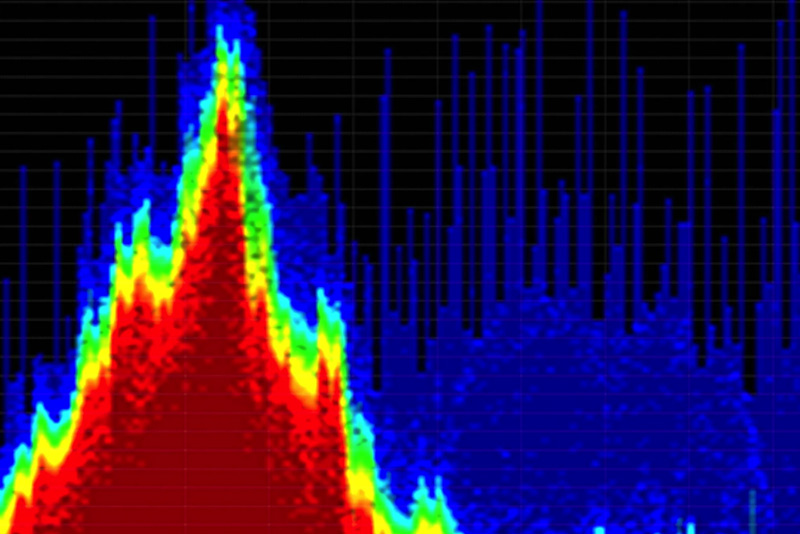
   A Cyber Electromagnetic Spectrum (CES) Assessment examines how the Electromagnetic Spectrum (EMS) and cyber operations (intentional as well as inadvertent) in a given locale might affect the system being analyzed. As noted on the Global Positioning System (GPS)/Global Navigation Satellite System (GNSS) Assessments page, while having served as the principal performer on a project, we documented GPS/GNSS/Ground-Based Augmentation System (GBAS) issues for various International Air Transport Association (IATA) codes. For one IATA code, we were asked to review the findings from a Frequency Spectrum Management Panel (FSMP) Working Group regarding GPS interference/signal degradation during the Area Navigation (RNAV) GNSS instrument approach phase, which resulted in unreliable Actual Navigation Performance (ANP). We have also conducted assessments regarding potential sources of interference. For example, the CES Assessment scrutinized, among other facets, the civilian emitters in the area, as these can often, inadvertently, cause Electromagnetic Interference (EMI) and Radio Frequency Interference (RFI). The survey/assessment of Civilian Electromagnetic Infrastructure (CEI) is non-trivial. Transmitters and/or radios that have sub-optimal designs and/or are improperly operated can produce spurious emissions outside of their intended operating frequencies. In particular, for a locale with a congested spectrum, this could easily segue to lower than desired signal-to-noise ratios. Of note, a high-power transmitter in the locale can also result in receiver overload (the receiver is overwhelmed by the transmitter). The CES Assessment further examined the Strategic/Critical Infrastructure (SCI) in the area, as power lines (particularly when faulty, damaged, or degraded, etc.) can generate excessive noise.


   Under normal circumstances, a portion of the noise emanating from SCI (e.g., electric utility equipment) stems from unintentional emitters. Specifically, while the involved emitter does indeed intentionally generate an internal radio signal, it does not intentionally radiate/transmit it. Examples of such SCI emitters include certain types of Switch-Mode Power Supplies (SMPS), which typically incorporate a voltage switching regulator (which transforms the incoming power supply into a pulsed voltage that is then smoothed, via the utilization of capacitors, inductors, and other elements, so as to convert electrical power efficiently), as well as various microprocessors utilized within certain of the electric utility equipment. The SMPS high-frequency switching generates undesired high-frequency energy/noise (to be filtered) that can, potentially, be radiated/transmitted. The noise that travels via power lines and/or that is radiated is referred to as Conducted EMI and Radiated EMI, respectively. The noise that resides within the radio-frequency range (and emitted as radio waves) is referred to as Radio-Frequency Interference (RFI). Depending upon the locale, the emitters from the electrical grid can constitute a substantive source of interference; we have conducted numerous studies regarding EMI/RFI.


Source of figure: IEEE Spectrum

[Spectrum] Congestion, [Band] Oversaturation, Signal [Control], Temporal [Volatility] (COST)

   Persistent saturation of a particular band(s) can be problematic. Accordingly, as part of our CES Assessment, we utilize a Spectrum Congestion Risk Scoring Model (SCRSM) that scores congestion per band, per locale, and per time frame. Some of the risk factors considered, among others, include: (1) Band Criticality (e.g., non-essential, medium-priority, mission-critical), (2) Band Occupancy (e.g., by percentage intervals), (3) Emitter Density (e.g., sparse, low, moderate, high, extreme), (4) Noise Floor Elevation (e.g., negligible, noticeable, severe/persistent), (5) Temporal Volatility (e.g., predictable, variable, highly dynamic/bursty), (6) Signal Control (e.g., government-controlled, mixed-ownership, civilian-controlled), etc. Once a score from the SCRSM is determined, the issue of mitigation is often addressed. For example, high band occupancy for a critical band might necessitate looking at alternate bands. If the band is mission-critical, the current architecture might need to be re-examined and re-designed. If the CEI poses an ongoing significant risk, then policy coordination might be a prudent course of action.


   The described SCRSM and COST analysis approach are applied to several facets of the CES Assessment. For example, communications are also a key aspect of CES Assessments. As an example of some of our considerations, let us take the simple case of an area with extensive Bluetooth traffic, wherein 2.4 GHz was avoided and 5 GHz became the favored band. However, there were numerous Wireless Local Area Networks (WLANs) competing for the 5 GHz band, and in this particular case, the lower portion of the Federal Communications Commission (FCC) Unlicensed National Information Infrastructure (U-NII-1) and the upper portion (U-NII-3) became congested very quickly. For the study and simulation conducted, the remaining U-NII-2 was congested with portable weather radar (IEEE channel numbers 120, 124, 128). Accordingly, IEEE channel numbers 52, 56, 60, 64, 100, 104, 108, 112, 116, 132, 136, 140, and 144 of U-NII-2 were congested (at spreading factor 7, no packets were received, and even at spreading factor 12, no packets were received) so that communications, via smart auto-switching, devolved to cellular mobile data. Co-tier interference (e.g., between neighboring femtocells, which are small, low-power cellular base stations) and cross-tier interference (among different tiers of the network, such as between femtocells and the larger picocells, metrocells, microcells, or macrocells) were also emulated so as to force the involved communications to return to Channel 40 (between 5170 and 5250 MHz) on U-NII-1. The Berkeley Packet Filter (BPF) was utilized to monitor the channels, specifically Channel 40. This forcible return to Channel 40 constituted, potentially, an Achilles heel (i.e., a prospective cyber kill chain). Of course, the referenced spectrum for this example would differ by country for international work, but the notion is comparable. Likewise, the described scenario involving Bluetooth can be applied for other communication technologies.


Operational Vulnerability Assessment (OVA) and Risk Characterization Analysis (RCA)

   In addition to the spectrum usage patterns discussed, the CES Assessments involve mapping the involved systems. This necessarily entails, at a higher-level, network diagrams that illuminate Cyber Electromagnetic (CEM) dependencies (at a more granular level, waveform discernment becomes critical as well). The significance of CEM cross-domain dependencies, set against the backdrop of the referenced network diagrams, is that of potential impacts (e.g., sequential topology effects) from single points of failure, which need to be identified. This constitutes a substantive portion of the Operational Vulnerability Assessment (OVA) and Risk Characterization Analysis (RCA) aspects (a.k.a., Criticality and Exposure Analysis) of the CES Assessment. Depending upon the client, RCA is also referred to as Risk Exposure Analysis or Cross-Domain Exposure Analysis, and the other referenced acronyms also have equivalent names. Ensuing outputs typically involve risk heat maps and priority areas to harden/make more resilient. Overall, this process can be referred to as a Cyber Electromagnetic Spectrum OVA (CEMS-OVA or CES-OVA) or, simply, a CES Assessment.


We perform assessments

   Over the past several years, we have performed assessments at airfields around the world. In particular, our core competencies center around Cyber Electromagnetic Spectrum Assessments, Energy Resiliency Assessments, and Global Positioning System (GPS) Assessments. Our assessment methodologies have been affirmed by various governmental teams around the world and were feted at a scientific academy.

  • Our vision

    To become a premier service provider to the aviation community.

  • Our mission

    To provide value-added proposition to the aviation and aerospace sector, via certain assessment competencies.

  • Our assessment core competencies

    We are continually honing our skills in the field and are active within our sector. We specialize in using AI-centric tools and methodologies in our assessment work.

  • Our dedication to the community-at-large

    Our work over the past several years has had a definitive impact in enhancing resiliency at airfields around the world. We look forward to the privilege and honor of serving the aviation and aerospace communities as well as the global community-at-large for many years to come.

Contact Us

by email: info@vtaviationaerospace.com
by phone: +619 550-3058

Our Collaborative Space/
Tech Accelerator Activities
have taken place in

San Diego:

1855 First Avenue, Suite #103,
San Diego, CA 92101

Orlando:

101 South Garland Avenue, Suite #108,
Orlando, Florida 32801


We cherish our prior efforts and look forward to our new activities!